Infrakit TRUCK™ app for Android

Infrakit TRUCK™ app for Android

Infrakit TRUCK™ app is a part of the Infrakit system and it’s used for tracking and managing project logistics. Use the Infrakit TRUCK™ app and keep track of movements and activities of your vehicles on Infrakit OFFICE™.

Currently there are two modes in the app: Manual and Automatic. These modes are related to the organization which the user belongs to. You can select which mode you want in Infrakit OFFICE™. Selected organization mode is valid for all users of that organization.

Manual mode – this means that truck driver has full control over ride. Driver chooses material, volume, volume unit and task for the ride, and also starts and finishes ride on button press.

Automatic mode (Advanced Trucks) – driver has no control over trip, everything was set up earlier by fleet manager, the only thing the driver needs to do is drive.

Download Infrakit TRUCK™ app for Android devices on Google Play store »

Book a Demo

Discover how Infrakit connects your entire infra project operations and drives value to every part of your business.

Using Drone Data with Planning

Using Drone Data with Planning

A construction site is efficient only when the data it uses is accurate and up-to-date. Intelligent project information can be shared and received in real-time using Infrakit. Maps are a useful tool to understand the big picture, but most map services have outdated basemaps or satellite imagery and that might confuse more than help the perception. Drones are already a common tool at work sites, but the data is usually hidden from all others than the data specialists. By using ortho images and point clouds collected with drones as basemaps in construction softwares, all workers can utilize the data to its full potential. Once completed tasks are documented and shared quickly, all parties and workers can understand the benefit of data capture and will be able to take full advantage of the knowledge.
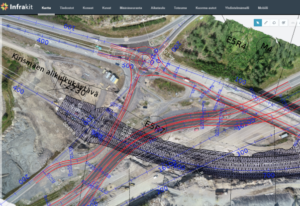
Accurate and timely drone data is used to design temporary constructions and traffic arrangements during the constantly changing construction site.

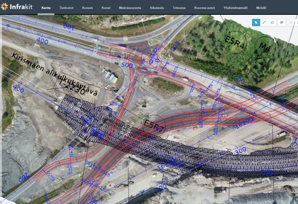
Thanks to Pointscene, you can bring your drone or aerial ortho images into Infrakit as a basemap, combining your plan and the up-to-date status of the construction site. By bringing in the real images, activities and status of all site-related items will be visualized and integrated together with the design model. For example, stockpile information or site equipment, that can be visually located and taken into account in work tasks and temporary logistics or route planning.

“Once I started actively using our drone at our site, I cannot imagine why I wouldn’t use it anymore. Instantaneously the drone became irreplaceable as it provides new tools for site documentation and monitoring” –

states Tero Maijala, who is the Head Surveyor for Destia’s E18 Turku ringroad project. In this almost 10 kilometer long, 39 MEur project Maijala is in charge of land surveying and machine control data management on the site.

You will never need to doubt if you data is accurate and up-to-date, when you have drone data to support your designs in the same interface. The actual state of the construction site is comprehensive and easy to communicate to all parties. Once the drone data is updated regularly enough when the site progresses, e.g. weekly or monthly, Infrakit users can see their heavy machinery on the map working in the correct place instead of the middle of the woods or ocean of the outdated basemap imagery.
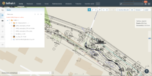
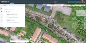
Up-to-date aerial images bring the plans and designs to life. The design is now much easier to understand, as it is for sure in the right place.

Progress is easily tracked and managed once you have up-to-date imagery of the area under construction. Infra-construction projects are done so rapidly, that there is no point of making 3d models of all the phases and all changes into the designs. Of course worksite visits are necessary, but you can expand the observation and knowledge with a new and wider perspective from above. Regularly updated aerial images are great for training new workers and for public announcements. “We have our orthophotos in Pointscene and now all parties can access the data even straight into their design software.” Maijala shares his experiences. “Up-to-date drone maps bring designs and plans alive into the actual world” Maijala continues. Once the data is updated with the newest one, old data is still used for comparison and archiving. Detailed images can be useful evidence for possible insurance cases.
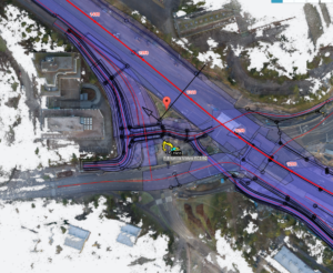
Also point cloud data from laserscanners or photogrammetry can be converted into ortho images and integrated into Infrakit . © SRV Infra Oy / Kehä1 Keilaniemi

If you are already using drones at you worksite or you are curious of utilizing drone data in your Infrakit project, please contact Pointscene or your Infrakit contact person and we’ll set up a demo and put your drone data on the map!


Pointscene.com

Lauri Hartikainen, CEO
lauri@pointscene.com +358 50 5435444

Reeta Ojala, Customer Experience Lead
reeta@pointscene.com

Book a Demo

Discover how Infrakit connects your entire infra project operations and drives value to every part of your business.

We are pleased to announce the opening of our new office in Sydney

We are pleased to announce the opening of our new office in Sydney

Espoo 14th August 2019

Infrakit Group Oy opens a new office in Sydney. In addition to existing offices in Finland, Sweden, Norway, Netherlands and France, we are opening an office in Sydney, Australia.

The office address is 14 Narabang Way, Belrose NSW 2085, Australia. Jan-Erik Björni has been appointed General Manager for Australia. He worked before at Infrakit as a Key Account Manager in Helsinki office.

Infrakit is a cloud service for infra-project management and it offers a solution in handling large amounts of data between different parties, contractors, subcontractors and owner, enabling everyone to have the latest version in real time.

“Infrakit is widely used in Europe and continues to take new market shares, the opening of the office in Sydney strategically strengthens Infrakit’s presence on the Australian market”, says Jan-Erik Björni.

“It is a big step for a company to open its first office in a new country and we are optimistic about the new opportunities Infrakit can bring to the Australian market and its customers. You have to have local presence to build relationships locally. Even with today’s teleconferences and virtual meetings, it is difficult to build long lasting relationships without meeting your customers face to face”, says Managing Director Jan-Erik Björni.


Contact information:

General Manager Jan-Erik Björni, tel. +61 (0)443986386, jan-erik.bjorni@infrakit.com

Vice President, Business Development Pasi Joensuu, tel. +358 44 768 4424, pasi.joensuu@infrakit.com


Photo by Laura Cros

Book a Demo

Discover how Infrakit connects your entire infra project operations and drives value to every part of your business.

DCS Finland changes name

DCS Finland changes name

Espoo 14th August 2019

The company will be called Infrakit Group Oy from 8th August 2019 and the old name is no longer in use. Infrakit is already known as the company’s product name and the name change reflects the company’s growth and internationalization. In addition to the Espoo headquarters, Infrakit Group has subsidiaries in Sweden, Norway, Estonia, the Netherlands, Serbia and France. In August, subsidiaries were also established in Germany, Infrakit Deutchland GmbH and, in Australia, Infrakit Pty Ltd.

”The company continues to grow strongly. This year we have already established four new subsidiaries. This indicates that the Infrakit cloud service is in high demand internationally. In particular, we focus on countries where technology adoption, such as machine control and GNSS, is already at a good level, ”says CEO Teemu Kivimäki.

The business ID will remain the same. The change does not require any action on the part of the customer.

For more information, please contact CEO Teemu Kivimäki, teemu.kivimaki@infrakit.com, tel. +358 50 344 6465

www.infrakit.com

Book a Demo

Discover how Infrakit connects your entire infra project operations and drives value to every part of your business.

Meet us at Intergeo 2019!

Meet us at Intergeo 2019!

Infrakit is going to participate again at the Intergeo trade fair that is held in Stuttgart, Germany this year. Land surveying companies will gather in the trade fair center of Stuttgart on 17th – 19th of September where they will be showcasing the newest software, methods and tools in the field. You will find us in the exhibition hall 1, stand number K1.033 You’re welcome to meet us!

You can also book a meeting with us in advance by sending e-mail to jan@infrakit.com or by calling to +31 655 73 55 00

Book a Demo

Discover how Infrakit connects your entire infra project operations and drives value to every part of your business.

New Feature: Measuring distance to breaklines

New Feature: Measuring distance to breaklines

We’re always listening to our customers and trying to understand their needs in order to create the best possible solution for them. It is because of this that we’re presenting a new feature for our Infrakit FIELD application.

Motivation behind this feature
Measuring distance to breaklines is important because it’s a stepping stone for us in the direction that we ultimately want to achieve and that is: Measuring distance to .dxf model.
So imagine, a surveyor walking and he always knows the distance between his current location and the model.

How to use it
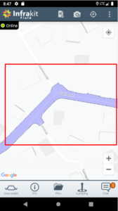
To get a taste of this feature, you just need to go to the app and load a model from your files tab.

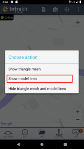
Long press the model until this dialog pops up.

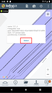
Select “show model lines” option and then click whichever line you want to start measuring your distance to. You will see the line’s information and blue “select” button. Press it!

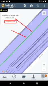
Now you can see that the selected line has turned green and in your top-right corner you can see your current distance to that line in meters. You can choose to measure distance to that line, select another one or unselect the current line.

Let us know if this feature and our ultimate goal for it is something that you’re interested or if you think we can change something or make it better in some way!

Book a Demo

Discover how Infrakit connects your entire infra project operations and drives value to every part of your business.