Infrakit and Initial Information Models

Infrakit and Initial Information Models


Carefully gathered and applicable initial data models is the cornerstone of infrastructure projects

Initial data that is both solid and usable is the precondition for a project to succeed within budgeted costs. Poor-quality initial data lead to poor-quality designs and from there to additional costs and delays in schedule in the construction phase.

The Finnish National InfraBIM Requirements 2015 part 3: “Requirements on Initial Information” is about gathering and harmonizing initial data into an easy-to-access digital material: initial information model. The guidelines describe the best practices related to the initial information model, but it also leaves room to implement it with various software solutions.

The raw material for the model is procured through multiple sources, for example: different registries and terrain measurements. The raw material is handled and then formed into the model by harmonizing the material into open formats and to the modern coordinate system (typically ETRS in Europe).

Example harmonizing the material:

A single InfraModel3 mesh model is transformed from a 2D map of water maintenance material (built from multiple DWG files) — National InfraBIM guidelines 2015

Finally the harmonized material – initial infomation model – consists of a group of open format files, which portray the desired area clearly for the design phase. At the moment the most used open format file types in Finland are InfraModel3/LandXML, GT file, DWG/DXF and IFC. As an addition to the model files itself, a model description in text form (Word or PDF) is linked to the initial information model, which reports the accuracy of the initial data and executed editing procedures.

Utilizing Infrakit

The best way to gather initial data and constructing the initial information model is to use Infrakit. Initial data model is gathered, which includes the 3D material and the required reports in folder structure approved by InfraBIM guidelines. On Infrakit the model is easy to view on map and 3D display. The designer in the next phase can download it on his computer as a whole or file-by-file to be used in any design program.
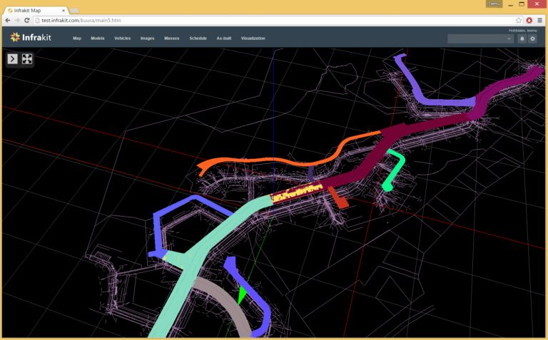
3D view on Infrakit.

Infrakit manages harmonized material checking. For example the success of coordinate conversions can be visually checked. You can also check that the material is successfully transcribed into an open format file type from the original design system. With Infrakit the designer or the project owner can verify the initial information model quality assurance. For the project owner the finalized model is easy to procure and validate as well as easily applicable in the next phase.

You can read my previous post about the InfraBIM guidelines here.

Book a Demo

Discover how Infrakit connects your entire infra project operations and drives value to every part of your business.

Promotion of Adriatic Almanac for Civil Construction

Promotion of Adriatic Almanac for Civil Construction

Infrakit participated in promotion of regional Almanac for year 2015/2016.

The Almanac – PUT plus – is becoming popular in ex-Yugoslavian markets, because it is one of its kind. It is good mix of academic, professional and commercial texts. Structure of the almanac is a combination of a magazine and a catalogue. Introduced in this issue are some of the biggest companies from the civil engineering sector in the region.

Infrakit introduced itself with article spread over three full pages. Concerning a small initiative about new technologies in Balkan civil construct sector, we consider that it was important to participate in the almanac, too. We explained the benefits of Infrakit application as a part of BIM platform, and passed knowledge about advantages of 3D guidance machine control systems and how Infrakit helps out every participant in construction process.

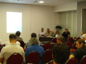
Event took place on 24th of July in Park Hotel in downtown Belgrade. We had a chance to meet all the event participants, consisted mostly from the representatives of the companies introduced in the almanac. We made contacts, gave out our promotional material and arranged further meetings with some of them. All in all, my impression is that guests also wanted to get to know each other since there is no big regional association gathering for civil engineering market, promotion was a good event for networking and we made valuable contacts there.

Although almanac has about 300 pages, it is easy to browse through and interesting to read. About 60 regional companies from civil construction sector took part in this second issue of the almanac, some with advertisements, and some with academic columns. The number of road and railroad construction companies is significantly higher in this issue than before. Almanac is very welcomed as a way to make up lack of communication and big events from the field in the region.

You can read the PUT Plus article here (in Serbian): PUT Plus – Infrakit

Book a Demo

Discover how Infrakit connects your entire infra project operations and drives value to every part of your business.
INTERMAT Paris 2015 Exhibition

INTERMAT Paris 2015 Exhibition

This April Teemu and I visited the Intermat Exhibition in Paris for 2 days. Our main goal was to talk with the major manufacturers for machine control systems and to see what kind of possibilities there are in the European market for Infrakit. It was interesting to see that there were not many software-related companies exhibiting at this fair, I would have expected otherwise as digitalization is such a huge trend nowadays.

We were able to talk with all companies that are active in the machine control business and very good talks they were indeed. All of those parties agreed with the fact that open communication will be demanded by customers in the near future. Openness and interest to companies like Infrakit will be a topic for the upcoming years. Some admitted that this is already necessary right now.

Another issue we noticed was that the machine manufacturers are now offering more and more machine control systems that are build-in from the factory. They see the growing demand for this and build-in from factory has many advantages. Especially cables are much better protected than when the systems are installed after delivery or on existing machines. This gives the customer a more reliable system as a whole.

From the conversations with these manufacturers we found out that they also see there’s a good market for open communication – as with Infrakit. At the same time it is necessary for them to make a well-thought choice of brand. Most of them have already made such a choice, which results in the fact that they have chosen between either Trimble, TopCon or Leica.

Furthermore we had contact with several companies supplying software or service for infra design. These companies are very interesting as to see what kind of cooperation we might have with them in the future.

All in all it was a successful exhibition for us and for Infrakit’s future in the international markets. Can’t wait to see what the next Intermat event has to offer.

Book a Demo

Discover how Infrakit connects your entire infra project operations and drives value to every part of your business.
Images on Infrakit OFFICE™

Images on Infrakit OFFICE™

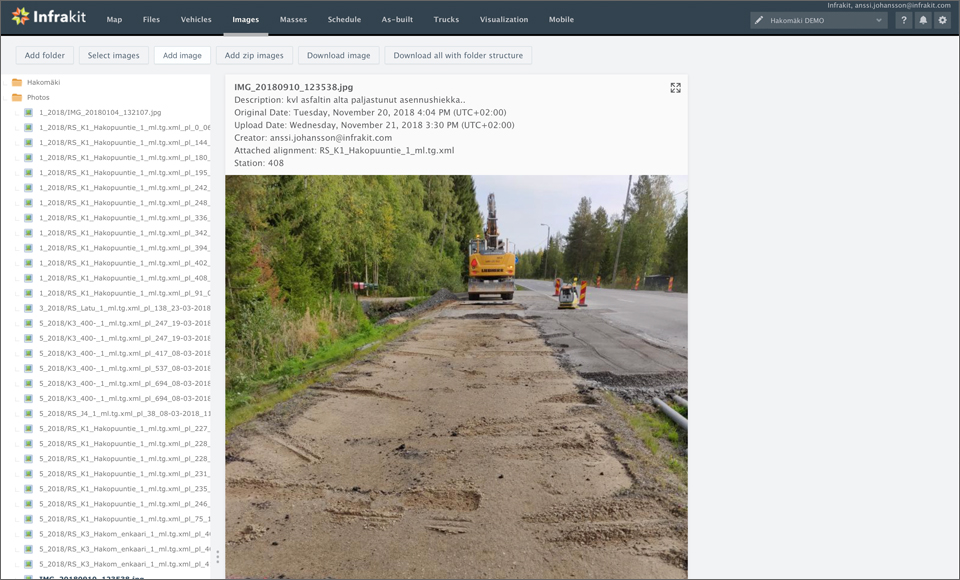
There are several uses for images taken at the project site. You can document the existing structures and area before work on the site starts and during the project you can document all work stages. When you are using the Infrakit FIELD™ app for Android or iOS you can easily take images at the site and upload them to your project with the relevant metadata like location information included in them.

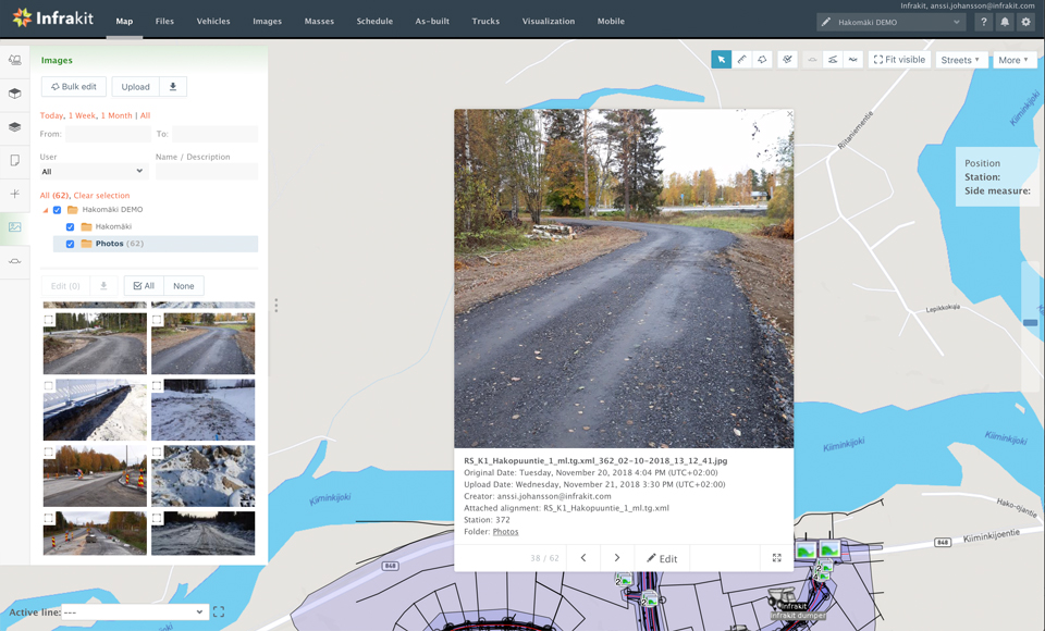
You can view the images with a file explorer that allows you to download all the images for storage elsewhere. You can also view all the images on the map and by clicking on an image you get a preview of the picture and more information about this specific picture. It’s also possible to display it fullscreen or edit the information about that picture. Infrakit also support 360 images if you have the necessary equipment to produce them.

Download Infrakit FIELD™ Lite on Apple App Store »

Download Infrakit FIELD™ for Android devices on Google Play store »

Book a Demo

Discover how Infrakit connects your entire infra project operations and drives value to every part of your business.
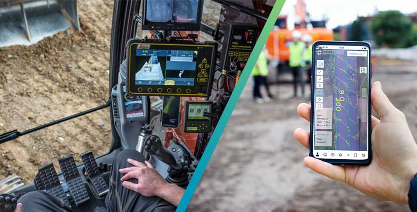
Hexagon’s Geosystems division and Infrakit Group Oy have entered in a technical cooperation

Hexagon’s Geosystems division and Infrakit Group Oy have entered in a technical cooperation

Hexagon’s Geosystems division and Infrakit Group Oy have entered in a technical cooperation to improve integration between their cloud platforms, field and machine control solutions.

The agreement will enable efficiency gains to innovative construction companies who are looking to improve their construction processes with digitalisation.

The new agreement will allow direct interaction between the Infrakit cloud platform and Hexagon’s Heavy Construction solutions, including Leica Geosystem’s products such as the Leica ConX cloud-based collaboration tool, the Leica MC1 machine control solution, the Leica Captive surveying field software and the Leica iCON site construction field solution.

This cooperation creates additional value for construction companies by enabling a straightforward and easy-to-use integration of mixed fleets of heavy construction machinery.

“We are very excited to have a closer cooperation with Hexagon Geosystems, a leading technology provider of sensor, software and autonomous solutions for the construction industry. Together with our partners, our goal is to work towards the success of our customers and the sustainability of our industry. We see that the way forward is a more open world with integrations between all systems and tools used on site,” says Teemu Kivimäki, founder and CEO of Infrakit Group.

“It is a great stride forward to be able to simplify the usage of the right data, strengthen workflows and increase our customers’ productivity from small to larger infrastructure projects for a sustainable future together. Hexagon Geosystems are very happy to work closer with Infrakit to serve our common customers better, today and for the future,” says Magnus Thibblin, President Hexagon Geosystems Machine Control division.

About Infrakit

Infrakit is a cloud service for infrastructure construction projects with a vision of a sustainable infra-industry. Infrakit offers disruptive real-time situation awareness and data flow to and from the construction site, shared by all project parties – infrastructure owner, general contractor and subcontractors. Infrakit is an independent platform, connecting all brands of CAD systems, surveying equipment and machine control systems.

About Hexagon

Hexagon is a global leader in sensor, software and autonomous solutions. We are putting data to work to boost efficiency, productivity, and quality across industrial, manufacturing, infrastructure, safety, and mobility applications. Our technologies are shaping urban and production ecosystems to become increasingly connected and autonomous — ensuring a scalable, sustainable future.

Hexagon’s Geosystems division provides a comprehensive portfolio of digital solutions that capture, measure, and visualise the physical world and enable data-driven transformation across industry ecosystems.

Hexagon (Nasdaq Stockholm: HEXA B) has approximately 21,000 employees in 50 countries and net sales of 3.8bn EUR. Learn more at hexagon.com and follow us @HexagonAB.

Damyanti Rathore
July 13, 2021

Book a Demo

Discover how Infrakit connects your entire infra project operations and drives value to every part of your business.