The New Infrakit version brings more CDE features and enhanced 3D experience!
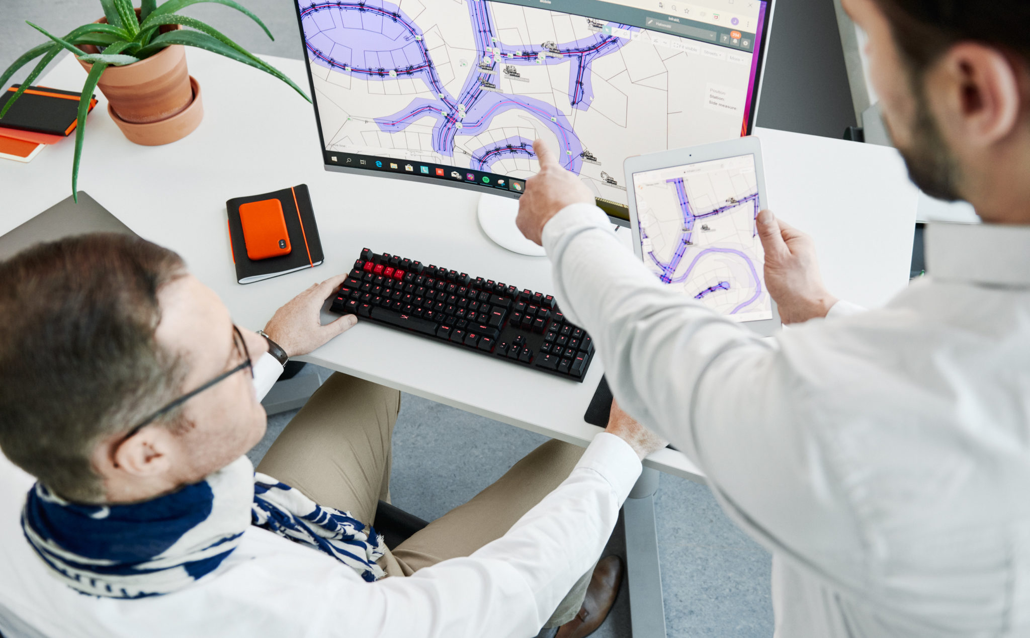
The New Infrakit version brings more CDE features and an enhanced 3D experience! 

Release blog posts may not be the most popular ones we’ve got, but we could argue that they are high value providing hidden gems for those that do open these. Seems that you are one of those pioneers, and forerunners of the industry, so congratulate yourself on being on the tip of the iceberg, by educating yourself to be the ”digitalization champion” who rides the tide!  

For release 3.8.2 of Infrakit OFFICE, we focused on making features that help manage all project documents in Infrakit, not only the ones you would visualize on the map. Together with that, we have enhanced the 3D BIM viewing. In other words, these features enable you to work faster,  collaborate better, and be the star of your project! 


Optimize your data management with new CDE features

It’s no big secret that data management is the key to successful projects. This time we focused to enhance our CDE features by adding you an opportunity to set and manage properties for your files. 

Was it either file categories of Design Disciplines, Model maturities, or phases of the project, property management saves you a ton of time. Add your custom property as a number, text value, or in a list of options. 

Check how to use it from the video below! 


Simplify your mountain of information 

Infraprojects tend to have quite an overwhelming amount of files… Thus, filtering and sorting out the ones you don’t need in the UI brings simplicity.  

To enable this step by step, we developed another CDE feature, which enables you to make any file or folder dispappear from the visualization apps.  As an example, you can use the Infrakit as single source of truth platform for all the project files. Store and manage the revisioning of the native drawings that are not meant for map projection. With this feature those files are not bugging the users of the Map page. 

We also introduced handy left-click menus on web UI, make sure you don’t miss that one! 

The video below once again will show you a quick and easy way of using this feature! 

Become a superior collaborator with enhanced 3D’s and point clouds 


Wouldn’t you want to be the champion, who makes everyone in project-wide collaboration feel happy and safe? Yea, that is precisely why (once again), we used a ton of focus on making Infrakit help you to be the champion. 

Infrakit’s high-power 3D engine can smoothly render your map and 3D data in one view on any modern hardware (yeah, that’s including phones and tablets). The 3D view now also enables you to see the station numbers of alignments, enabling finding the right spot on the project even handier. On top of these, the new version enables you to select multiple point clouds to be visualized at the same time!  

These features not only make the designs and visualizations of the site look good but you as well! 


Check the more in-depth list of new features and improvements of this version from our Knowledge Base

Jere Syrjälä
March 13th, 2023

Book a Demo

Discover how Infrakit connects your entire infra project operations and drives value to every part of your business.

Climate Fund – €6 million capital loan to Infrakit for the development and commercialisation of sustainability functionalities for boosting emissions reductions in infrastructure building

Climate Fund – €6 million capital loan to Infrakit for the development and commercialisation of sustainability functionalities for boosting emissions reductions in infrastructure building

The Finnish Climate Fund has decided on a capital loan of up to 6 million euros to Infrakit Group Oy for the development of sustainability functionalities in their data management service, as well as for boosting the software’s international deployment. Improving the efficiency of transport and the utilisation of machines and materials can reduce the emissions of infrastructure construction sites by an estimated 5%.

Infrastructure building refers to the construction of, for example, transport routes, logistics centres, energy infrastructure or industrial structures. The sector’s annual emissions in Finland are approximately 1.4 Mt CO2eq, of which roughly 55% is generated by the fuel consumption of machinery and vehicles.

Infrakit offers data management services for infrastructure projects, particularly for reducing the duration and costs of construction. ”Until now, we have been able to promise our customers savings of approximately 20% in overall infrastructure building costs by improving the efficiency of operations with our service. Many projects have also been completed ahead of schedule, like the 70-million-euro project on Highway 3. Now we want to bring the same benefits to sustainability”, says Infrakit’s CEO, Teemu Kivimäki.

Infrakit’s sustainability function will offer more precise information and tools for boosting emissions reductions to construction companies and infrastructure managers in Finland and abroad. The service lets its users leverage climate and environmental data as well as measure and anticipate the emissions generated by their operations.

”Infrakit’s comprehensive data management service is one way of boosting the sustainability perspective in the construction sector. For example, cities and municipalities could use the service to set requirements and goals for builders regarding their emissions. Our investment accelerates the growth of an emissions-reducing solution and enables the development of new sustainability functionalities”, says CEO Paula Laine of the Climate Fund, shedding light on the reasons behind the investment decision.

Infrakit’s solution

Infrakit Group Oy is a company established in 2010 that offers cloud-based data management services to infrastructure construction sites. Infrakit’s solution has already been used in over 3,000 Finnish and international projects worth more than 30 billion euros in total.

The emissions reductions achieved by Infrakit are indirect: its technology enables the recognition of emissions but the ultimate emissions reductions depend on the corrective action taken by the company’s customers instead of directly from the technology or product of the company being financed. Infrakit’s data-based management features offer tools for determining the customer’s carbon footprint, monitoring actual emissions and optimising emissions during the project’s implementation. By using this data, Infrakit’s customers are able to decrease their emissions.

The project’s estimated emissions reduction potential is based on the improvement in infrastructure building efficiency achieved by the data model platform provided by the company, which can for example reduce the fuel consumption of machinery at the construction site. The magnitude of the emissions reductions achieved in a single infrastructure building project is approximately 0.6 kt CO2eq. If Infrakit’s business plan succeeds, its ten-year cumulative emissions-reduction potential is approximately 3 Mt CO2eq. The emissions-reduction benefits brought by the new sustainability functionality currently under development would be realised in addition to this estimate, but the assessment of their magnitude involves uncertainties, so they have not been included in the emissions-reduction estimate above. The project targets markets both in Finland and abroad but Infrakit believes that most of its growth will be achieved abroad.

The total investments in the company’s growth and development plan in the next few years are estimated at €12.6 million, consisting of the Climate Fund’s capital loan, €5 million in equity funding from one of the company’s current shareholders and grants from Business Finland and the Centre for Economic Development, Transport and the Environment.

The Climate Fund’s capital loan of up to €6 million has a convertibles option and will be allocated to the development of an emissions-reducing functionality and the acceleration of the software’s international deployment. The interest on the Climate Fund’s capital loan is priced at the market rate and the capital loan also includes a conversion right.

For additional information, please contact:
Saara Mattero, Director, Communications and Sustainability, tel. +358 400 114 777 saara.mattero@ilmastorahasto.fi

Anssi Johansson, VP of Marketing, tel. +358 40 592 9933, anssi.johansson@infrakit.com

The Finnish Climate Fund is a Finnish state-owned special-assignment company. Its operations focus on combating climate change, boosting low-carbon industry and promoting digitalisation. The Climate Fund invests in large-scale projects in which the fund’s investment is crucial to enable the project’s realisation in the first place, on a larger scale or earlier than it would with funding from elsewhere.

Infrakit – Your digital transformation partner. Infrakit is an industry-disrupting digital platform to increase infrastructure construction productivity. We are driven by the goal of a sustainable infra industry – while offering 20% savings in total project costs. Our customers include the most advanced construction companies and infrastructure owners in the world. We have been helping our customers to digitalize their infra projects since 2010 – over 30 billion euros of infra assets has been built with Infrakit in more than 3000 projects in 13 countries.

Anssi Johansson
February 8, 2023


Book a Demo

Discover how Infrakit connects your entire infra project operations and drives value to every part of your business.
Kalasatama-Pasila project – een belangrijke stap naar een emissievrije bouwplaats

Kalasatama-Pasila project – een belangrijke stap naar een emissievrije bouwplaats

Emissiedoelstellingen op organisatieniveau worden min of meer gemeengoed in de infrastructuursector. Maar op het zetten van concrete, belangrijke stappen om deze doelstellingen te bereiken hebben we moeten wachten.

Ambitieuze koolstofneutraliteitsdoelstellingen kunnen alleen worden verwezenlijkt wanneer de middelen om de emissies te verminderen via concrete projecten worden ontwikkeld.

Een belangrijke stap naar koolstofneutraliteit

Destia, hoofdaannemer van het alliantieproject Kalasatama-Pasila in Helsinki, heeft samen met het duurzaamheidsteam van het project de grote stap gezet van ambitie naar praktijk.

In samenwerking met andere projectpartners experimenteert Destia nu met emissiecontrole op basis van productiegegevens, wat niet alleen een nauwkeurigere en hoogwaardigere emissiecontrole mogelijk maakt, maar ook een lichter proces voor het genereren van controlegegevens.

Van raming tot verificatie van emissies

In de toekomst kunnen de emissies beter worden geoptimaliseerd door ze te verifiëren. Deze optimalisatie vereist metingen, en zal ons uiteindelijk in staat stellen de voor de aanleg van infrastructuur vastgestelde doelstellingen inzake koolstofneutraliteit te bereiken.

Wij hebben ons meer toegelegd op het ontwikkelen van oplossingen om de doelstellingen inzake koolstofneutraliteit te bereiken. Een onderdeel van deze verbintenis is de ontwikkeling van op productiegegevens gebaseerde emissiecontrolesystemen.

Lees meer

Jere Syrjälä
January 31, 2023


Book a Demo

Discover how Infrakit connects your entire infra project operations and drives value to every part of your business.

Ontwikkelingsproject Rijksweg 3 van €70 miljoen jaar eerder dan gepland voltooid

Ontwikkelingsproject Rijksweg 3 van €70 miljoen jaar eerder dan gepland voltooid 

Bouwwerkzaamheden aan het project van de Finse Rijksweg 3 startten in de zomer van 2020 en zijn in november 2022 voltooid, een jaar eerder dan gepland. Volgens de oorspronkelijke planning zou oplevering plaatsvinden in de herfst van 2023.

De snelweg door Hämeenkyrö werd uitgebreid door de aanleg van een 10 kilometer lange tweebaansweg met vier rijstroken, waarbij er rekening moest worden gehouden met drie spoorwegovergangen en elf bruggen. Infrakit heeft gedurende het hele project deel uitgemaakt van de implementatie, vanaf de ontwerpfase tot het toezicht op de bouw en de kwaliteitsborging.

Het dagelijks gemiddeld verkeersvolume (DGV) op de secties van Rijksweg 3 langs de verbinding bedraagt nu tussen 2.500 en 16.900 auto’s per dag. In 2040 zal het dagelijks gemiddeld verkeersvolume naar verwachting zijn toegenomen tot tussen 2.800 en 24.700 auto’s per dag. Het aandeel van zware transportvoertuigen in het totale verkeer varieert van 6 tot 16 procent (Vayla.fi).

Het project werd aanbesteed door het Finse Transportagentschap en uitgevoerd door Destia. Het nieuwe weggedeelte zal de reistijd tussen Helsinki en Vaasa verkorten en de doorstroming en verkeersveiligheid verbeteren.

Grote infrastructuurprojecten vereisen uitgebreide planning

Goede planning is van essentieel belang om vertraging van projecten te voorkomen. Infrakit is vanaf het begin betrokken geweest bij het project met het verzamelen van ontwerpgegevens.

In een steeds verder digitaliserende industrie, maakt de software van Infrakit het eenvoudig om in verschillende fases te werken. De software stroomlijnt de informatievoorziening vanaf de ontwerptafel door implementatie naar rapportage.

Hoewel de bouw werd uitgevoerd volgens het gebruikelijke aannemersmodel, werden de ontwerpoplossingen in samenspraak bedacht en ontwikkeld. Het digitale platform faciliteerde daarbij het ontwerpproces.

Doordat alle planners toegang hadden tot kaarten en 3D-modellen, was iedereen voortdurend op de hoogte van de ontwerpplannen.

Infrakit kan ook worden gebruikt om de uitvoering en nauwkeurigheid van gegevens te monitoren. Zo kan de voortgang van het werk bijna in realtime worden bewaakt. Bovendien kunnen nauwkeurige gegevens worden vergeleken met de ontworpen oppervlakken en niveaus in overeenstemming met de structurele toleranties.

Het digitaliseren en stroomlijnen van informatievoorziening beïnvloedt de besluitvorming en follow-up. Dit draagt in grote mate bij aan het halen van deadlines.

Soepel communiceren op locatie vermindert vertragingen

Reageren op uitdagingen en veranderingen en beslissingen nemen tijdens het project zijn essentieel om op schema te blijven. Tijdens de bouw worden er op locatie enorme hoeveelheden gegevens gegenereerd. Het organiseren en delen van deze gegevens versnelt werkzaamheden aanzienlijk.

De verzamelde gegevens maken het veel eenvoudiger om een beeld van de actuele situatie op te stellen en het werk te controleren. Besluitvorming is daarnaast gemakkelijker wanneer er voldoende contextuele gegevens en feiten zijn om besluiten te onderbouwen.

Met het platform van Infrakit kunnen gebruikers orthofoto’s uploaden als kaartbeelden en hierop plannen visualiseren. Zo is gemakkelijk te controleren of wegen, leidingen en structuren zijn aangelegd waar deze zijn ontworpen. Dit helpt met het bewaken van de uitvoering en voortgang van werkzaamheden zoals bestrating, wegmarkeringen en afwerkings- en verhardingswerkzaamheden.

Duurzame ontwikkeling transformeert de bouwindustrie

Duurzaamheid is een essentiële factor geworden bij de ontwikkeling van wegwerkzaamheden. Bij het Hämeenkyrö-project is veel aandacht besteed aan het hergebruiken van bouwmaterialen, wat het Finse Transportagentschap ondersteunt met herziene duurzaamheidsrichtlijnen. Infrakit maakt deel uit van deze trend. Geoptimaliseerde informatiestromen en efficiënt gebruik van middelen leveren materiaal- en energiebesparingen op.

Kosten kunnen worden verminderd door gerecyclede materialen te gebruiken. Bovendien bespaart dit op het gebruik van natuurlijke hulpbronnen, doordat afval kan worden hergebruikt. In Hämeenkyrö zijn geschikte materialen uit de lokale omgeving gebruikt voor de constructie van geluidsbarrières en oppervlakteafwerking.

“Het is geweldig om te zien hoe het project van onze klant is geslaagd door het gebruik van de nieuwste digitale processen. Natuurlijk heeft een efficiënt geïmplementeerd project ook een aanzienlijk lagere koolstofvoetafdruk,” aldus Teemu Kivimäki, CEO van Infrakit.

Infrakit stimuleert de milieuvriendelijkheid en duurzaamheid van infrastructuurprojecten door de inzet van middelen te optimaliseren. Zeker in het licht van hard gestegen prijzen voor bouwmaterialen, leidt efficiënt materiaalgebruik tot aanzienlijke kostenbesparingen. Lees meer over duurzaamheid bij Infrakit.


Anssi Johansson
December 19, 2022


Book a Demo

Discover how Infrakit connects your entire infra project operations and drives value to every part of your business.

Infrakit 3.8.1. is out, and here is what you should know about it!

Infrakit 3.8.1. is out, and here is what you should know about it! 

We are delighted to have the Infrakit version 3.8.1. up and running. There are some great new features for you to have a seamless experience in your daily work using Infrakit. We gathered the three most important highlights for you to quickly grasp on, what the new version holds and how it will make your life at the site better! 

Brand spanking new IFC models on map  

It is unfortunately true, that many times 3D rendering is waay too complex to manage, especially on mobile over a bad network. Therefore, we are super happy to bring the new IFC Outline generation for you, which enhances the mobile experience! 2D rendering is important especially on mobile, to avoid complexity and long waiting times. With the new version and reparsing, you will have a collaboration model in 2D, earthworks, and structures in one view. Easier and faster than ever, right?


Supercharged communication with new annotation tools 

Communication with the new annotation tools for Saved views is made easier than ever. Internally they help you for example sharing agendas in site meetings, showcasing risks and traffic plans, or requesting information from designers, externally you can share traffic arrangement information. 


The power of Saved views is greater than ever, and that power is in the palms of your hands! 

A new era of Security – SSO Login  

Managing your project information in Infrakit is now almost as safe as keeping your gold in Fort Knox… Now it is time for you to call your organization’s IT gurus and tell them to connect your organization’s Azure AD to Infrakit!  

Why? You know better than anyone, that it is everyday life on a site where subcontractors are coming and going, and project staff changes. With Azure AD connection, data security is ensured with an up-to-date user register that automatically syncs up with your organization’s register. 

See in-depth list of new features and improvements of version 3.8.1. here 

Jere Syrjälä
December 5, 2022

Book a Demo

Discover how Infrakit connects your entire infra project operations and drives value to every part of your business.

Welcome the new Infrakit version 3.8.0, where construction collaboration has been taken into a whole new level!

Welcome the Infrakit version 3.8.0, where your construction collaboration is brought to a whole new level!

We are delighted to release the Infrakit version 3.8.0 to general availability! This version brings many long-awaited features, such as turbo-charged 3D visualization, mobile access to saved views, and wider support for Kilometer posts of Railway stationing. And these are only to name a few of the absolute highlights of the release. 

Fast loading and rendering of 3D visuals 

Infrakit has now an intelligent way of optimizing the visualization of 3D models. Firstly, the time for model files to open is now drastically quicker. Secondly, all content opened renders about 10x faster! This improves your experience of 3D visualization on large job sites. 

Please note the new Shade button that highlights the edges of the structures also when they are under other models.  

Psst… look at those even more awesome point clouds! 

Mobile Saved Views 

Collaboration from the field can now be done at a whole new level. With mobile access to saved views, you will be able to select a subset view of the site and share it with all the users you want to collaborate with on the field. Were you either inside your office or on the field with only a mobile phone in your pocket, saved views will save a ton of time and effort from you by showing only the necessary information that another user wanted to share with you.  

Railway kilometer posts 

If you are using Infrakit in a railroad construction project, this is an absolute must-have for you guys, and we are happy to have it ready for you. Now that all the kilometer posts, hence, stations are displayed in Infrakit, locating documents and all the other information is a peace-of-cake. Further improvements to this feature are upcoming in later releases! 

Check the more in-depth list of new features and improvements of this version from:  https://support.infrakit.com/help/infrakit-office-version-3-8-0 

Jere Syrjälä
November 18, 2022

Book a Demo

Discover how Infrakit connects your entire infra project operations and drives value to every part of your business.