News: Infrakit projects in the Netherlands

News: Infrakit projects in the Netherlands

Infrakit reaches its first project in the international markets

Combination Jansma/Roelofs/VanSpijker has been awarded the contract for De Centrale As Noord 1. In this project they will be using Infrakit Construction Collaboration Cloud.

Project owner is Province of Fryslân and the contract manager of this project will use Infrakit as well. Infrakit will be used from the design phase until construction and as-builts. In this project the engineering and project management will be done by Roelofs and the earthwork will be done by Jansma. Van Spijker will do the concrete elements.

One platform – Infrakit – enables the use of BIM throughout the project and will increase efficiency for all participants – and vastly decrease errors and costs.

We congratulate the allience of these three great companies of this nice order and wish you all a successful execution of this project!

Book a Demo

Discover how Infrakit connects your entire infra project operations and drives value to every part of your business.

News: Infrakit Projects in Finland

News: Infrakit Projects in Finland

Infrakit cloud service is the key tool for our clients in hundreds of infra projects.

Infrakit uses open formats allowing the most effective tools to be used in each phase. All relevant information can be managed and shared in Infrakit service in open formats.

Managing and sharing all relevant information in Infrakit allows better collaboration in all construction phases in all your projects.

With Infrakit the knowledge and expertise of all parties is adequately utilized throughout the project
Infrakit allows real-time information to be shared with all members of the project in all construction phases. Infrakit is available on any PC and mobile device with any browser, but also on Infrakit Android App found on Google Play Store (read more here).

In Finland our customers are industry forerunners, e.g. Finnish Transport Agency, The Regional Centres for Transport and the Environment, cities and municipalities, major construction companies, surveying companies, consultants and designers.

Cases: four Infrakit projects
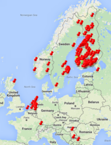
Infrakit projects

E18 Hamina-Vaalimaa. The main contractor YIT utilizes Infrakit. Digital designs, as-built information and other plans and documentation are available through Infrakit. The map-based and platform-independent Infrakit system helps YIT to boost productivity by efficient information management.

In Pietarsaari road 68 project all of the designs, documents and as-built data is shared on Infrakit during construction. When real-time information is shared in Infrakit, the communication between project owner and contractor is more efficient and the collaboration is seamless. Digital information, documentation and reports are available at any point of time in open formats.

A large global stabilizing contractor maximizes the benefits of digital design and as-built information. Infrakit service provides live view of project designs, maps, pipenetworks and the data collected by the surveyors and 3D machine control system. Vital project data management and work documentation is automatic.

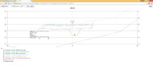
A large design company uses Infrakit for enabling continuous interaction with the project owner. Collaboration in Infrakit results in purposeful designing by bringing the project owner into the decision-making process more actively and efficiently. Viability of designs is easy to control with our in-built tools. Designs can be viewed in 3D-view, map view and cross section tools.


Infrakit is the easy-to-use solution for utilizing digital designs and as-built information and documentation in infrastructure projects.

We are constantly developing our service and remain active in infra forums such as BuildingSmart forum in Finland. We are currently working in a project to collect best practices for BIM project owners in Finland. Contact us for more examples on how to use digital information for your benefit.

In the next blog post you can read about our on-going international projects.

Always share up-to-date data on all mobile and desktop devices.
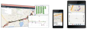
Infrakit – map based service for collecting and sharing up-to-date
information on all mobile and desktop devices.


Book a Demo

Discover how Infrakit connects your entire infra project operations and drives value to every part of your business.

News: Infrakit Server Update

News: Infrakit Server Update

Infrakit version 3.0.1.3 published on 16th of Aug

We updated the Infrakit server and now there is 4 times more capacity and memory meaning major improvements for user experience. You will see the response time is notably faster making the use of Infrakit swifter and more efficient – on both PC and mobile devices.

Infrakit App new UI

Infrakit Android App new UI

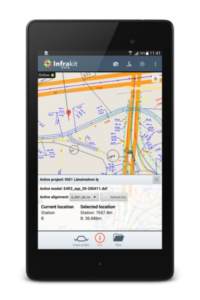
The Infrakit App UI has been updated adding value to the usability and user experience. You can find the App on Google Play Store search by Infrakit or clicking here.

Book a Demo

Discover how Infrakit connects your entire infra project operations and drives value to every part of your business.

Finnish BIM Requirements for Infrastructure 2015 Released

Finnish BIM Requirements for Infrastructure 2015 Released


The Common InfraBIM Requirements 2015 are Moving Finnish Infra Industry Forward

The first 7 parts of the guidelines for infrastructure information modelling were released on 5th of May 2015. The publisher and developer behind it is the buildingSMART Finland’s infrastructure business group – including, but not limited to: Finnish Transport Agency, large Finnish municipalities, construction companies, consultancies and technology companies. Also Infrakit is a part of the buildingSMART Finland operations and yours truly is a deputy board member of the infrastructure business group.

The development and publishing of the InfraBIM Requirements are moving Finnish infra industry forward and now the possibilities are there for a leap in productivity. It is now up to the industry itself on how it will implement the guidelines and the responsibility lies on the project owners. If the requirements are referred in the requests for tender, they will be widely taken into execution thus enabling a potential for increasing performance. The Finnish model is also recognized abroad, which I see is the most advanced model out there – even if there is still a lot of room for improvements. The world will never be 100% perfect as these guidelines won’t be either, but even with this much the guidelines enable us to take the construction industry to the next digital level.

Open Formats as a Requirement

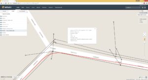
In part 2: “General requirements” open formats is the first thing mentioned and highlighted: “It is an absolute requirement to use open formats as a default”. This is the core of the guidelines that enables the development of innovative solutions. A good example of these possibilities is the use of pipe models (IM3 PipeNetworks), which enable data sharing from the designer to the on-site machine control systems and installation crew’s tablet devices.

IM3 -pipe model in Infrakit

The guidelines are written on a high abstraction level on purpose so that different software and operatives can execute them in their own way. Using the InfraBIM Requirement model and Infrakit industry players can easily succeed in the transition towards digital construction. Next week I will publish another post on how Infrakit makes the initial data gathering phase easier for the project owner and the design engineer with the use of Requirements part 3: “Requirements on initial information”.

The InfraBIM Requirements 2015 will be soon published in English, in the meanwhile read the article about it here.

Book a Demo

Discover how Infrakit connects your entire infra project operations and drives value to every part of your business.

Infrakit Android App

Infrakit Android App

Infrakit Android App available at Google Play!

You can find the new Infrakit App from Google Play with keyword Infrakit. This is a beta version of the new app that you can use to browse your Infrakit models, alignments and background maps on your Android mobile device. The app has a new camera feature which allows you to take photos on site. The photos are then linked to your location and will show on Infrakit map as icons. Taking photos is available also in offline mode so you don’t need network for taking photos in areas with bad connection. When you go back online the photos are automatically synced to Infrakit.

User interface from June 2015

Infrakit Android App now supports the direct use of GNSS receivers such as Javad Triumph-2, Javad Triumph-1, Trimble R10 and Topcon GR-3. You can use the external receiver with the Infrakit app and make measurements and validations with your precise location. The technology behind it is that a connection is established between the GNSS receiver and Infrakit App via Bluetooth, which allows integration development with other receiver manufacturers in the future. If you have another receiver in use, please let us know and we will build the support for it too!

The core purpose of the app is to provide management and surveying staff a tool alongside the web service to extend the benefits they get from using Infrakit on-site. Now they can access the design data and maps faster and easier while adding comments and pictures to notes while terrain visits. Soon the app will have a new user interface and layout, which makes the use even more effortless.

Edit. 2nd of August 2016: See our newer blog post of developing the App, its surveying abilities from here (see how far we have come in a year!) and some user experiences from here.

Book a Demo

Discover how Infrakit connects your entire infra project operations and drives value to every part of your business.