We are pleased to announce the opening of our new office in Sydney

We are pleased to announce the opening of our new office in Sydney

Espoo 14th August 2019

Infrakit Group Oy opens a new office in Sydney. In addition to existing offices in Finland, Sweden, Norway, Netherlands and France, we are opening an office in Sydney, Australia.

The office address is 14 Narabang Way, Belrose NSW 2085, Australia. Jan-Erik Björni has been appointed General Manager for Australia. He worked before at Infrakit as a Key Account Manager in Helsinki office.

Infrakit is a cloud service for infra-project management and it offers a solution in handling large amounts of data between different parties, contractors, subcontractors and owner, enabling everyone to have the latest version in real time.

“Infrakit is widely used in Europe and continues to take new market shares, the opening of the office in Sydney strategically strengthens Infrakit’s presence on the Australian market”, says Jan-Erik Björni.

“It is a big step for a company to open its first office in a new country and we are optimistic about the new opportunities Infrakit can bring to the Australian market and its customers. You have to have local presence to build relationships locally. Even with today’s teleconferences and virtual meetings, it is difficult to build long lasting relationships without meeting your customers face to face”, says Managing Director Jan-Erik Björni.


Contact information:

General Manager Jan-Erik Björni, tel. +61 (0)443986386, jan-erik.bjorni@infrakit.com

Vice President, Business Development Pasi Joensuu, tel. +358 44 768 4424, pasi.joensuu@infrakit.com


Photo by Laura Cros

Book a Demo

Discover how Infrakit connects your entire infra project operations and drives value to every part of your business.

DCS Finland changes name

DCS Finland changes name

Espoo 14th August 2019

The company will be called Infrakit Group Oy from 8th August 2019 and the old name is no longer in use. Infrakit is already known as the company’s product name and the name change reflects the company’s growth and internationalization. In addition to the Espoo headquarters, Infrakit Group has subsidiaries in Sweden, Norway, Estonia, the Netherlands, Serbia and France. In August, subsidiaries were also established in Germany, Infrakit Deutchland GmbH and, in Australia, Infrakit Pty Ltd.

”The company continues to grow strongly. This year we have already established four new subsidiaries. This indicates that the Infrakit cloud service is in high demand internationally. In particular, we focus on countries where technology adoption, such as machine control and GNSS, is already at a good level, ”says CEO Teemu Kivimäki.

The business ID will remain the same. The change does not require any action on the part of the customer.

For more information, please contact CEO Teemu Kivimäki, teemu.kivimaki@infrakit.com, tel. +358 50 344 6465

www.infrakit.com

Book a Demo

Discover how Infrakit connects your entire infra project operations and drives value to every part of your business.
Meet us at Intergeo 2019!

Meet us at Intergeo 2019!

Infrakit is going to participate again at the Intergeo trade fair that is held in Stuttgart, Germany this year. Land surveying companies will gather in the trade fair center of Stuttgart on 17th – 19th of September where they will be showcasing the newest software, methods and tools in the field. You will find us in the exhibition hall 1, stand number K1.033 You’re welcome to meet us!

You can also book a meeting with us in advance by sending e-mail to jan@infrakit.com or by calling to +31 655 73 55 00

Book a Demo

Discover how Infrakit connects your entire infra project operations and drives value to every part of your business.
New Feature: Measuring distance to breaklines

New Feature: Measuring distance to breaklines

We’re always listening to our customers and trying to understand their needs in order to create the best possible solution for them. It is because of this that we’re presenting a new feature for our Infrakit FIELD application.

Motivation behind this feature
Measuring distance to breaklines is important because it’s a stepping stone for us in the direction that we ultimately want to achieve and that is: Measuring distance to .dxf model.
So imagine, a surveyor walking and he always knows the distance between his current location and the model.

How to use it
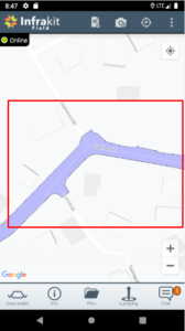
To get a taste of this feature, you just need to go to the app and load a model from your files tab.

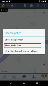
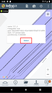
Long press the model until this dialog pops up.

Select “show model lines” option and then click whichever line you want to start measuring your distance to. You will see the line’s information and blue “select” button. Press it!

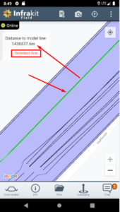
Now you can see that the selected line has turned green and in your top-right corner you can see your current distance to that line in meters. You can choose to measure distance to that line, select another one or unselect the current line.

Let us know if this feature and our ultimate goal for it is something that you’re interested or if you think we can change something or make it better in some way!

Book a Demo

Discover how Infrakit connects your entire infra project operations and drives value to every part of your business.
Brand spanking new Infrakit Knowledge Base

Brand spanking new Infrakit Knowledge Base


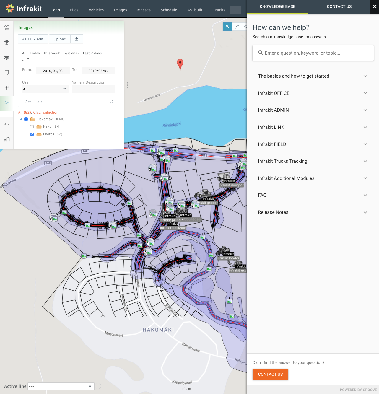
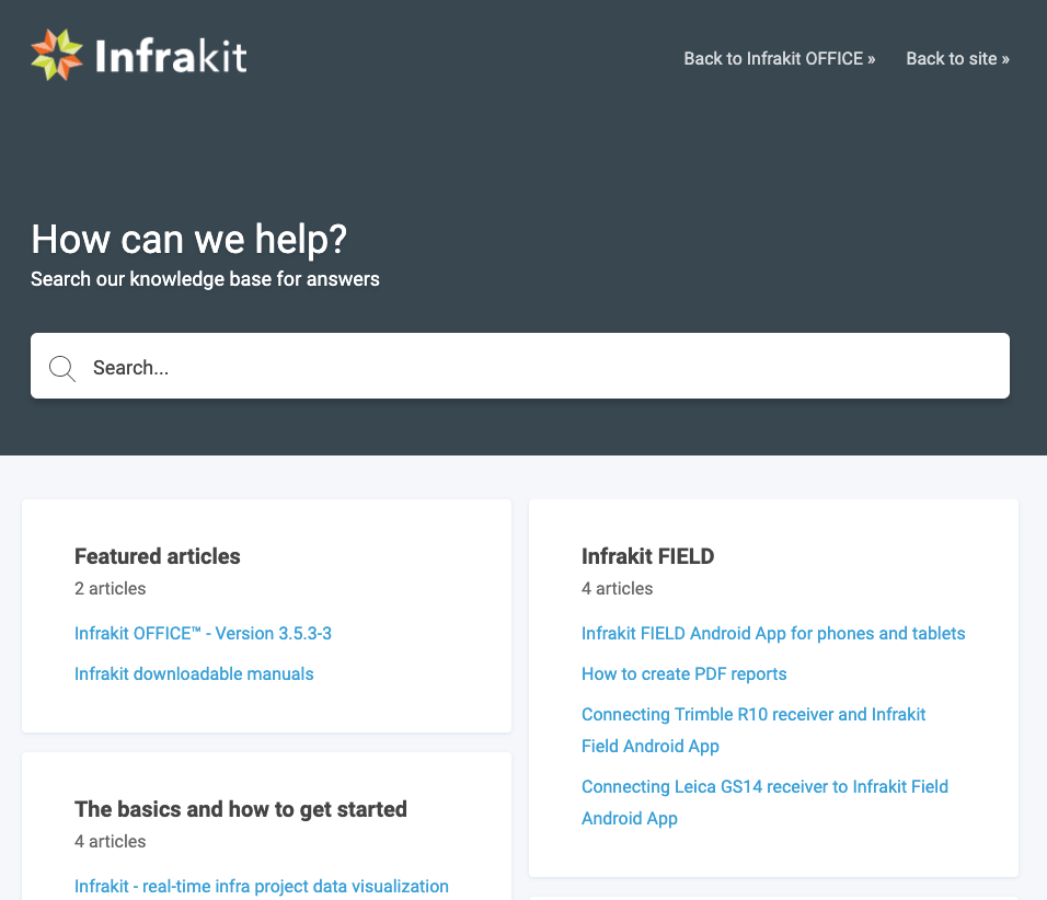
We’ve just published a Knowledge Base for Infrakit which covers all our solutions for infra-construction. You can read up on all the features and functionalities of Infrakit OFFICE™ and our Android and iOS apps. If you need to set up integrations to machine control systems there’s a whole section about Infrakit LINK™ and step-by-step instructions to get it done. Or maybe you just want to check out the latest release notes and additions to the FAQ.

You can also access the Knowledge Base directly in Infrakit by clicking the question mark on the bottom right corner.

Go check it out at https://support.infrakit.com/help

Book a Demo

Discover how Infrakit connects your entire infra project operations and drives value to every part of your business.
Learn more about vehicles on Infrakit OFFICE™

Learn more about vehicles on Infrakit OFFICE™


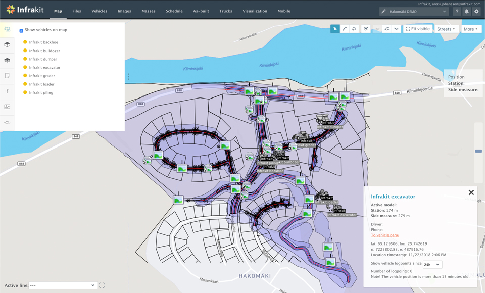
Once all the necessary design files have been added to Infrakit and can be viewed on the map the next logical step is to add all the vehicles operating at the project site. Once the vehicles have been registered they are listed on the map “Vehicles” tab and a color code indicates the status of the vehicle:

· Green: An active vehicle with active and working data connections to Infrakit. All assigned models have been synced between Infrakit and the machine.
· Red: Assigned models have not been synced between machine and Infrakit. Either sync is ongoing or waiting to happen or sync has failed, and data connections are down.
· Orange: Vehicle is activated for the project with latest models synced but it’s not online
· Grey: The vehicle is set to ‘on hold’ state or the vehicle is not activated for this project.

The separate “Vehicles” page gives an overview of the different vehicles registered on the project, but also gives access to more information about them:

The list of all vehicles registered to the project
The number of online vehicles
The overall efficiency of the vehicles on the project
The total amount of working hours registered by the vehicles.
Additional information about the vehicle (type, station location, last contact, efficiency, connection time and driver/additional information)
Button to “edit” the vehicle (only available for Admins)
Possibility to download locally on your computer the as-built points in format CSV, GT or XML for any given time range.
Efficiency: graph visualization of the efficiency of each vehicle compared to all.
Usage statistics: view for each vehicle, per week, their daily activity with information like exact time, starting/ending station and model used.
Manage rights: to define which models are accessible for each vehicle
Accuracy: detailed information about the as-built point loaded by this vehicle and its accuracy compared to the reference models.
So by having all the vehicles and work machines connected to Infrakit you get a real-time view of their activities on the work site. We support integration of machine control systems from vendors like Trimble, Leica, Topcon and Moba.

Book a Demo

Discover how Infrakit connects your entire infra project operations and drives value to every part of your business.