Infrakit BIM Services? – Meet our BIM-team!

Infrakit BIM Services? – Meet our BIM-team!

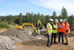
Photo: Infrakit BIM-team Visa Hokkanen, Ilkka Tieaho, Tero Maijala and Atte Kajander

We are happy to start our introduction series with our brand-new BIM-team, and in particularly with two true professionals in the field of BIM: VP of BIM services, Ilkka Tieaho (second on the left) and Senior BIM Specialist, Tero Maijala (third on the left). Even though both of them started their journey at Infrakit recently, working with Infrakit isn’t unfamiliar to them – in their previous careers both Tieaho and Maijala gained experience working in projects where Infakit was used. Together with the rest of the team one of their primary goals is to serve as a link between the clients and the remaining Infrakit staff. With their previous experience working on the customers’ side, they have gained valuable knowledge of the challenges and advantages that clients may face with Infrakit.

Tieaho, who started last August, says it has been a pleasure to notice how smoothly he was welcomed to his new work community. His working history contains a great deal of experience from designing and consulting, especially in the designing phase of construction projects. ”I see coming to work at Infrakit as a great opportunity to create something new. It has also been interesting to see how working with BIM looks like from a tech company’s point of view”, Tieaho reflects. One of the crucial strengths of Infrakit in his opinion is the company’s flexibility: ”We must continue to provide fast and close support to our clients.”

One of our most recent employees is Tero Maijala, who started his work last November. He says that moving over from working as a land surveying specialist at a worksite, to the other side of the table has felt like a natural choice. ” [before] I was building infra and now I’m beginning to build Infrakit – building things hasn’t stopped.” In his previous job Maijala has worked in close proximity with Infrakit almost daily since the beginning of the 2010s. In the period of the last six months he has seen a change in how the client’s viewpoint has become a stronger priority and wanted to be a part of the solution. ”The thing that me and Tero have in common is that we both believe Infrakit to be an excellent and functional solution in designing and construction projects”, Tieaho sums it up.

The mission of the recently created BIM-team is to help clients use Infrakit in their daily work. Vital in achieving this goal is organizing training sessions, providing consultancy and developing new and more functional customs so that our clients will gain added value with Infakit. Their first task has been contacting current clients and mapping out their needs, but Tieaho as well as Maijala both envision that in the future the BIM-team has also a lot to offer to the technical development.

Linda Hakala
January 14, 2020

Book a Demo

Discover how Infrakit connects your entire infra project operations and drives value to every part of your business.

Infrakit and year 2019 – it’s a wrap!

Infrakit and year 2019 – it’s a wrap!

Year 2019 has been a big success for Infrakit. We opened offices in five new countries, including large markets like France, Germany and Australia, all while staying profitable. Our team grew to a total of 32 construction and SaaS professionals.

Overall, digitalization of the infrastructure construction industry is progressing worldwide, with many governments pushing for requirements and legislation to adopt of BIM, to improve infrastructure construction quality and efficiency.

Infrakit BIM cloud enables an efficient digital production process for construction companies, connecting heavy machinery and all construction project stakeholders with up to date designs and real time view to site progress. In year 2019 we were especially delighted to see our customers win more projects with the competitive advantage they gained by moving faster than their competition.

For year 2020, we are looking to further expand our operations to new countries and to solidify our position as the leading SaaS provider for the global infrastructure construction industry.

On behalf of the Infrakit team, a big thank you to all of our customers and partners for year 2019. I’m wishing you a happy and successful year 2020!

Teemu Kivimäki CEO and founder

Book a Demo

Discover how Infrakit connects your entire infra project operations and drives value to every part of your business.

Infrakit OFFICE™ – Version 3.6.1

Infrakit OFFICE™ – Version 3.6.1

Highlights
SokoPro–Infrakit integration

We are pleased to announce the integration between Infrakit and Sokopro. The wish of the integration came originally from customers in order to improve information flow between the two software companies.

The integration has been successful and is now available to all of our customers. According to Fernando Korpi, Development Manager from SokoPro: “the biggest benefits of the integration are increased efficiency and transparency in data management and to make our customers’ day-to-day work easier.”

“As a result of the integration, we hope for a long and fruitful cooperation with Infrakit in the future”, tells Fernando Korpi.

SokoPro is a cloud service for data management, sharing and archiving. All the prestigious construction companies and real estate developers are using SokoPro for data management in Finland.

Faster cross-sections

On big sites, where Infrakit is used also as project data hub, the users have experienced system being slow. Actionsare now taken as new cross section tool optimizes the amount of data it uses for calculation of cross-sections. Nowthe speed of the view is not depending on project size, rather the amount of models user have selected to view.

Watch a video here.

User configurable as-built table

User can now change the order of as–built table columns like explained on video below.

Watch a video here.

Model elevation

Activate the terrain models on map and right click on top of the model. The elevation of the active models on that spot is displayed on pop-up menu. Note that it might take couple of seconds.

Watch a video here.

Book a Demo

Discover how Infrakit connects your entire infra project operations and drives value to every part of your business.

Strabag visit in Finland

Strabag visit in Finland

Infrakit Group Oy welcomed a delegation From Strabag AG in our office and for a site visit to Destia on the Vt12 project near Lahti.

After the experience of working on two pilot projects with Infrakit, Strabag AG expressed the need for a visit in Finland, which took place on 11th and 12th November. We started with a great dinner on Sunday evening and had a great exchange of information on Monday at our office in Espoo. Strabag explained the systems they have created for the bidding phase of big projects. Furthermore, we showed them more what improvement can be done in design phase and on site.

On Tuesday it was time to visit the worksite of Destia to hear from Harri Taina how he is using Infrakit on his sites and why. Strabag considered this as very useful information and we will take this into the next project together.

Jan Van der Brandt
December 19, 2019

Book a Demo

Discover how Infrakit connects your entire infra project operations and drives value to every part of your business.

New 3D view in Infrakit

New 3D view in Infrakit

Collaboration in 3D visualization of Infrakit

The 3D collaboration model of Infrakit allows the client, the designer and the builders to visualize design files and review them in design and site meetings. The cutting and measuring functions provide tools for verifying interoperability of multi-discipline design. With 3D collaboration model available in browser, the client can monitor progress of the work and lead the design and construction projects while keeping the entity well under control. How does the new 3D view differ from its predecessor?
Our 3D view has been completely redesigned, and the new version provides better performance, free zooming for different levels of detail, and viewing Pointscene point clouds and orthophotos in the same view together with design data. Everything purely in the browser without separate software installations.

Other new features include measuring the area and fitting the design to the screen. Progress does not stop here; other small improvements are coming, e.g. camera management improvements are now underway.

Highlights of the new release

Drone flight plan

Drones are used frequently on modern construction sites for providing enhanced situational awareness. Infrakit cannow be used to create flight plans for drones – simply draw an area and export in KML format as on the following video:

User configurable map tiles

As a new feature Infrakit allows the project admins to connect customized map tiles for projects.

Pointscene integration

Infrakit–Pointscene integration with orthophoto map tiles was initially introduced in spring 2019. Now theintegration supports also point clouds created by laser scanning or stereogrammetry. The source for the point cloudis entered to the dialog on new visualization page.

Model properties on visualization

Due to the new release, Infrakit is now able to visualize model properties. At the moment they are visible only on the legacy visualization page, but will be available on the new visualization page later as well. Right click on top of the model for object properties dialog:

Read full release notes here.

Linda Hakala
December 19, 2019

Book a Demo

Discover how Infrakit connects your entire infra project operations and drives value to every part of your business.

What is meant by digital infrastructure construction?

What is meant by digital infrastructure construction?

Infrastructure construction has been considered a low-tech field, but significant changes have taken place in recent years. Due to the development of work machine automation technology in the 2000s, traditional land building production method shifted from digital 3D models into implementation before anybody even talked about digitalization. The leap in the 2010s is largely based on the development of consumer and cloud service technologies, as well as on infra construction applications capitalizing on the aforementioned. We now process infrastructure information models on mobile devices and monitor production in real time. During the past five years Destia has had approximately 50 construction projects annually that are being carried out utilizing information model designs and 3D machine control systems. We are on the forefront of digitalization in our industry.

Destia is a pioneer in model-based production, where digital road models and designs of earth
structures drawn up by designers are being transferred into production with construction machine control systems. The machines have an enhanced satellite positioning and 3D-contolling system, which the machine operator can use for high-accuracy constructing using 3D models. This method increases performance, improves quality and reduces material wastage. The designs, in other words, information models are being managed and shared by the machines through a cloud service, where the management and clients can examine the models and stay up to date on the progress of the projects.

A couple of years ago Destia started to develop and pilot a method of producing digital handover material during construction to replace the traditional quality documentation method done at the end of a project and to enable utilizing the materials in model-based systems in the future. Since then this method has rapidly gained a foothold in our projects. It was described in the Finnish Transport Infrastructure Agency’s infra model guidelines in 2017 and as a part of the Common InfraBIM Requirements of 2019, where the method has been refined and also included in earlier stages of infra projects requiring information exchange.

In Destia’s large-scale projects the model-based method is always implemented as thoroughly as possible and its features are continuously being developed. For example in the Vt 4 Kirri-Tikkakoski project the designs for dozens of bridges will go through the inspection and approval process of designers, construction management and the client entirely in a model-based method. This is being carried out for the first time in a project of this magnitude in Finland. Diverse utilization of drones as part of the model-based process has quickly become a part of the everyday procedure in all of our large-scale projects. Collecting and refining production data from separate sources has reached a new level, as comprehensive information about production is available via automatized analytics on project level as well as on company level.

The infra construction industry is, in fact very keen to benefit from new possibilities offered by digitalization, and individual leaps in development can be implemented in an agile fashion. For example VR headsets that we know from the gaming world have given a completely new dimension to understanding construction sites with an information model. In the future VR and AR headsets might very well become standard equipment on construction sites – the same way mobile devices are now used in examining information models and in documentation, utilizing positioning accuracy to centimeter level if necessary. At the moment it seems, however, that of all new construction site technologies the use of drones is growing most rapidly.

The notion of infra construction as an industry that is rigid and slow to develop can surely be discarded. The foundations for a new kind of digital infra field have now been created – the future will show where this development will take us.

Pasi Nurminen is the R&D Director of Destia Ltd. This blog is updated, and it was published earlier on destia.fi (in Finnish).

Pasi Nurminen
September 30, 2019

Book a Demo

Discover how Infrakit connects your entire infra project operations and drives value to every part of your business.